Navigation apps like Waze are trying to help motorists avoid hurricane flooding. But can people really rely on their smartphones to steer themselves out of a disaster zone?
Amid heavy rain from Florence, some smartphone or in-car map directions in recent days have sent people in North Carolina onto flooded roads and others closed to traffic.
Google-owned Waze said Monday it's worked with local governments and its own community of volunteer map editors to mark closures of more than 1,300 roads in North Carolina and hundreds more in South Carolina and Virginia.
But the North Carolina Department of Transportation warned in a tweet on Sunday night that Waze and other travel apps are unable to keep up with Florence-caused road closings.
Scroll down for video
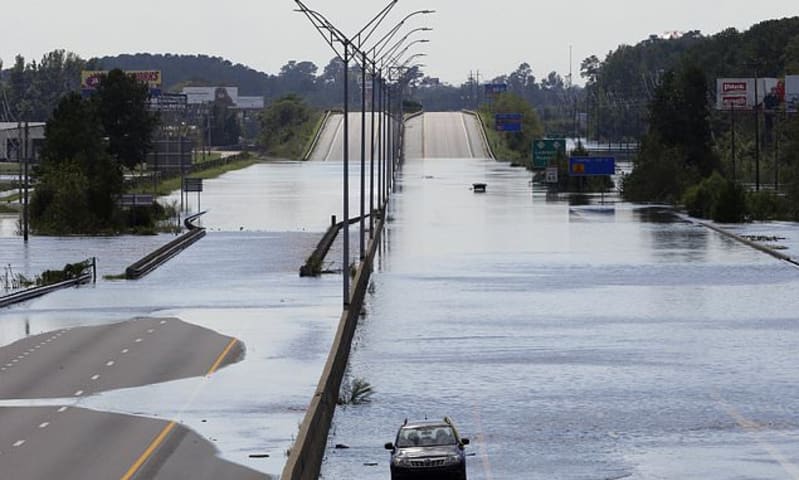
Above, flooded vehicles sit on a closed section of Interstate 95 in Lumberton, N.C., where the Lumber river overflowed following flooding from Hurricane Florence. Navigation apps like Waze are trying to help motorists avoid hurricane flooding
'It is not safe now to trust them with your life,' the agency warned after another Twitter user credited Waze for helping her avoid floodwaters during Hurricane Matthew in 2016.
'This storm, this flooding, these road closings are worse than Matthew, and they'll get even worse. Please stay safe!'
GPS-powered mapping systems have come a long way since updating an in-car navigation system required loading a compact disc with the latest geographic data.
More cars now come with navigation systems that are updated remotely and automatically. Other drivers rely on apps like Waze, Google Maps or Apple Maps.
It can still be hard to keep up with Mother Nature.
Miguel Melo, 22, said he was trying to drive from North Carolina to Florida to get to a friend's house when his SUV stalled out in high water in Lumberton.
He was waiting with his stalled car on a service road parallel to flooded Interstate 95.
'The GPS brought me here. It's stupid, and it's really bad. I'm in trouble,' said the Raleigh resident, who was parked in a dry spot of road.
State officials had warned in previous days that GPS was taking people down routes where roads had flooded and urged people to check a list of road closures before driving.
'A map in a catastrophe is only so good as its ability to capture real-time information either from sensors or people,' said Steve Goldsmith, a professor who directs Harvard University's Data-Smart City Solutions project.
WHICH NAVIGATION APP IS THE MOST EFFICIENT? Blogger Artur Grabowski collected data from 120 trips since early 2017. He measured his activity on Google Maps, Apple Maps and Waze to determine which navigation service got their users to their destination quickest. For each trip, he randomly selected an app to use and recorded this data in each trip: Grabowski collected a data set (pictured) based on 120 trips taken via Apple Maps, Waze and Google Maps since early 2017 Which app was randomly selected to follow for each trip (Apple Maps, Google Maps, Waze)
Estimated driving time for each app
Departure and arrival time
Traffic conditions (i.e. work commute hours or not)
Weather conditions (i.e. rain or not)
Driving type (i.e. >75% city, >75% highway, or mixed) From that data, he charted how often each app provided slower/faster trip time. He also measured how often the app got users to their destination on time and if not, how often users arrived at their destination later than expected. From that, he combined the estimated trip times with estimation errors to arrive at an error adjusted estimated trip time. This figure determined his key question: Which navigation app actually gets you to your destination most quickly? Based on his results, he determined that Google Maps gets users to their destination fastest .
Goldsmith, a former mayor of Indianapolis and former deputy mayor of New York, said the good news is that the flourishing of map apps has 'unlocked the ability of people to post information in real time and help their neighbors.'
Waze, in particular, relies on a large community of users inputting data about the latest road conditions.
Goldsmith said more government agencies are also entering two-way information sharing arrangements that help provide a better picture of what's happening on the ground, both for emergency responders and the travelers themselves.
'Individuals themselves will always collectively have more information than governments will,' he said. 'They'll have more information but less well organized.'
Local authorities say people shouldn't rely on apps to avoid flooding, even though Waze and others are working to stay up to date
After a bridge collapsed last month in Genoa, Italy, map providers such as Google were swift in updating their road maps, said Sam Hind, a researcher at the University of Siegen in Germany who studies navigation technology.
But disasters like Florence are trickier, Hind said.
'A single incident is obviously far easier to render and change than a general area that